
CAD Mapping
Standardizing for Success
The WADEPS dashboard is an incident-based tool for analyzing and comparing the use of force. A key strength of the system is the standardization of both use-of-force incident data points and call type labels for all community-police interactions.
In Washington, 78 public safety answering points opens a new window (PSAPs) provide support to local, county, state, and tribal law enforcement agencies by tracking and managing on-duty officer activity with a computer-aided dispatch (CAD) system. Each PSAP is an independent organization and their CAD dispatch codes, event types, and incident labels can be independent of each other, too.
Comparing Apples to Apples
In order to calculate incident-based rates of force based on community contacts, WADEPS is mapping each agency and PSAP’s call type labels to a corresponding incident type and incident detail listed in the approved data dictionary (1.9a and 1.9b, respectively).
When limited incident-level CAD data is received by WADEPS, the standardized dispatch code mapping enables the data to be automatically ingested to the data warehouse and displayed on the data dashboard. This provides agency-specific data to the public in a timely, accurate, and useful format.
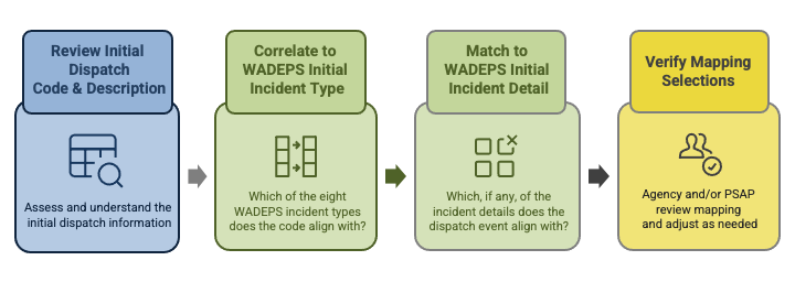
The WADEPS Initial Incident Types (1.9a) are:
- Offense against person
- Property offense
- Public order offense
- Vehicle stop
- Pedestrian stop
- Civil caretaking
- Warrant
- Other
The Initial Incident Detail options (1.9b), such as DUI for vehicle stop or burglary for property offense, provide additional context for each CAD event and reportable use-of-force shared with WADEPS.
Process and Example
Data Mapping Process
1. Agencies and/or PSAPs provide WADEPS with their full call type dictionary.
2. WADEPS compares call type labels to the WADEPS incident types and incident details in the data dictionary and determines the appropriate equivalency. Dispatch calls for administrative and non-community engagement tasks or incidents, such as motor pool assignments, are not included in the WADEPS data dictionary and will not be mapped.
3. Agencies and PSAPs will be asked to review their mapped results and provide clarification where needed.
Submit CAD call type files for mapping
Only one file per agency or PSAP is necessary. If a PSAP uses the same call type labels for all agencies it supports, only one file is necessary.
Excel or CSV format required. Include your organization name in the file name.
–> Upload from a PSAP or Dispatch Center
–> Upload from a law enforcement agency
Excel or CSV format required. Include your organization name in the file name.
–> Upload from a PSAP or Dispatch Center
–> Upload from a law enforcement agency
Example of Data Mapping

Why CAD Mapping is Important
Dispatch code mapping for CAD data will allow for meaningful agency-to-agency comparisons and accessible interpretation of large volumes of data
Public accessibility to and understanding of data is a core mission of the WADEPS project. Dispatch codes, acronyms, and abbreviations can be difficult to interpret, especially in large volumes and when the incoming data employs different systems of categorization.
Dispatch code mapping improves the public digestibility of police agency data by simplifying call types and incident-based data using language and naming conventions that can be more easily understood by the public.
Additionally, agency-to-agency comparisons must be appropriate to be meaningful. With hundreds of agencies and multiple variables—such as the number of officers, budget, population and physical area served—standardization of incident-based CAD data through dispatch code mapping improves the quality and accuracy of inferences drawn from the data and encourages “apple to apples” comparisons of similar agencies.